

Designed for rapid deployment at C2 and forward command levels - Combat tested and proven
The CSS Station is combat-tested and proven in real operational environments, delivering reliable satellite intelligence and GEOINT support under mission pressure. Designed for rapid deployment, it enables commanders to maintain situational awareness, support targeting and LOS analysis, and make informed decisions in fast-changing and contested conditions.

EW-RESILIENT OPERATIONS WITH A LOW SIGINT PROFILE
Designed to maintain connectivity, intelligence flow and mission effectiveness in electronically contested environments.

CSS STATION SIGINT-RESILIENT COMMUNICATIONS FOR CONTESTED ENVIRONMENTS
The CSS Station is designed to operate in SIGINT-challenged and contested environments, ensuring continuous access to satellite intelligence and GEOINT even under electronic warfare pressure. By leveraging four independent and complementary communication methods, the station maintains resilience, redundancy and operational continuity at C2 and forward command level.
The CSS Station supports:
-
Starlink for high-bandwidth, low-latency satellite connectivity in dynamic operations
-
SILVUS MANET for secure, mobile, line-of-sight and beyond-line-of-sight tactical networking
-
CDMA / LTE for cellular-based data transmission where infrastructure or deployable cells are available
-
Military-grade SATCOM / HF radio links for resilient, low-probability-of-intercept communications in denied environments
This multi-layered communications architecture allows the CSS Station to dynamically switch or combine links, ensuring uninterrupted intelligence flow, secure data transmission and reliable mission support regardless of threat conditions.

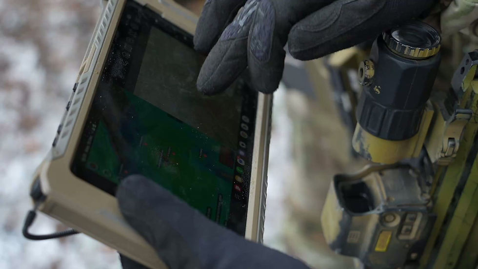
CSS STATION DIRECT INTELLIGENCE STREAMING INTO BMS
Forward-deployed Close Satellite Support enabling real-time GEOINT and satellite intelligence delivery into ATAK and DELTA for field operations.

DEVELOPED WITH AND FOR UKRAINE
Built in close cooperation with Ukrainian operators and shaped by real-world battlefield requirements to meet the demands of modern, high-intensity operations.

CSS IN MOBILE COMMAND VEHICLE
Deployable Close Satellite Support integrated into mobile command vehicles for on-the-move intelligence and C2 operations

BMS INTEGRATION & SATELLITE TASKING VIA VANTOR CONSTELLATION
Our solution connects Battlefield Management Systems directly with the Vantor satellite constellation, enabling tasking, data access and intelligence delivery within existing command workflows. Commanders and intelligence cells can request, receive and exploit satellite imagery and GEOINT without leaving their BMS environment, ensuring faster response times and tighter decision cycles.
By integrating satellite tasking with systems such as ATAK and DELTA, strategic space-based assets are transformed into a responsive operational tool. This capability supports time-critical ISR, target development, route and LOS analysis, and continuous situational awareness across tactical and operational levels.

SATELLITE PROCESSING & ANALYSIS POWERED BY CSS AI
Our CSS Station combines high-performance computing and AI-assisted GEOINT workflows to process satellite imagery rapidly and turn it into actionable intelligence products. The system supports automated change detection, object and pattern recognition, and prioritisation of areas of interest to help analysts identify potential enemy activity and high-value targets faster—while keeping a human-in-the-loop for validation and operational compliance.


Your operational Update
Enhance your operation with critical Intel


ATAK GEOINT
ATAK, CSS, combined with Vantor seamlessly combine to bring satellite intelligence, 3D terrain data, and real-time mission overlays directly into the hands of operators. This integration delivers faster decision-making, improved situational awareness, and a direct link between strategic space assets and tactical units on the ground.